Mean Dynamic Sea Level (MDSL) Package
Last Update: 01/24/2025
This POD computes model and reference product errors in time-mean dynamic sea level (MDSL) using a Generalized Three-Cornered Hat (GTCH)method. The POD computes MDSL errors for coastal, regional, and global domains.
Model Data
The package has been successfully tested for GFDL’s CM4 and ESM4 model data and below HighResMIP model output:
ECMWF-IFS-HR_e_hist-1950_vl_r1i1p1f1
In addition, functionality has been tested successfully for other CMIP6 HighResMIP models with varying grid specifications. The POD requires monthly zos output for 1993-2012, along with latitude and longitude information at grid centers, and vertices of the underlying grid.
Model output variable - zos : sea_surface_height_above_geoid
Model output is read in using a data catalog. We used the MDTF catalog_builder to generate data catalogs for the models tested for the package.
Observed/Reference Data
We use two reference MDSL products from the National Center for Space Studies (CNES) and Technical University Denmark (DTU). Minimal preprocessing is performed on DTU; the related code is provided at ~diagnostics/MDSL/Ancillary_Codes/
For the coastal MDSL error calculations, we use tide-gauge data as a reference in addition to the above-mentioned reference products. The reference datasets (MDSL and Tide Gauge) are available at ~diagnostics/MDSL/Ref_data/
Required Programing Language and Libraries
The package was coded in Python version 3.12.2
It requires the following packages: numpy, xarray, matplotlib, pandas, xesmf, os, intake, sys, yaml, cartopy.crs, cartopy.features, momlevel, sparse, cf_xarray
The custom functions needed are stored in below files:
~diagnostics/MDSL/gfdl_grid_fx.py
~diagnostics/MDSL/other_grid_fx.py
~diagnostics/MDSL/plot_fx.py
~diagnostics/MDSL/nch.py
Package Functionality
The core functionality of the package is contained in the MDSL.py file. The code routine of the MDSL.py file is segmented into seven sections.
Section 1
Sets up parameters. Here, you can pre-set parameters for the model data and the NCH calculation.
Make sure to change plot filenames in the MDSL.html to match the model name (ex:cm4) of choice.
Section 2
Reads in the “zos” data utilizing the pre-determined data catalog in the runtime configuration file (Several runtime config files are available as examples in ~diagnostics/MDSL/Example_files/). Once read in the model data is subset into the reference data time period (1993-2012) and the time mean is computed.
Section 3
Reads in the native and re-gridded reference products (DTU and CNES) from the [“OBS_DATA_ROOT”].
Section 4
This section sets up regions for the regional NCH calculations. The current version of the package sets up six regions that include - California, Leeuwin, Gulf Stream, Kuroshio, East Australia, and Norway.
Section 5
First re-grids reference data to the model grid on regional domains. Then calculates the MDSL error for the regional domain (NCH calculation). Also calculates the coastal NCH using tide gauge information. Finally, plots the outputs for each region (see Figure 2).
Section 6
First re-grids the model to a global 1-degree or 0.5-degree grid (based on the “rez” parameter in Section 1). Then calculates MDSL error globally and produces a plot similar to Figure 3.
Section 7
Closes the catalog files and disposes of the variable reference.
Section 8
Prints the successful run of the package and exits from the system.

Figure 1: A schematic showing the MDSL diagnostic’s functionality.
Diagnostic Outputs
The diagnostics provides regional and global MDSL outputs.
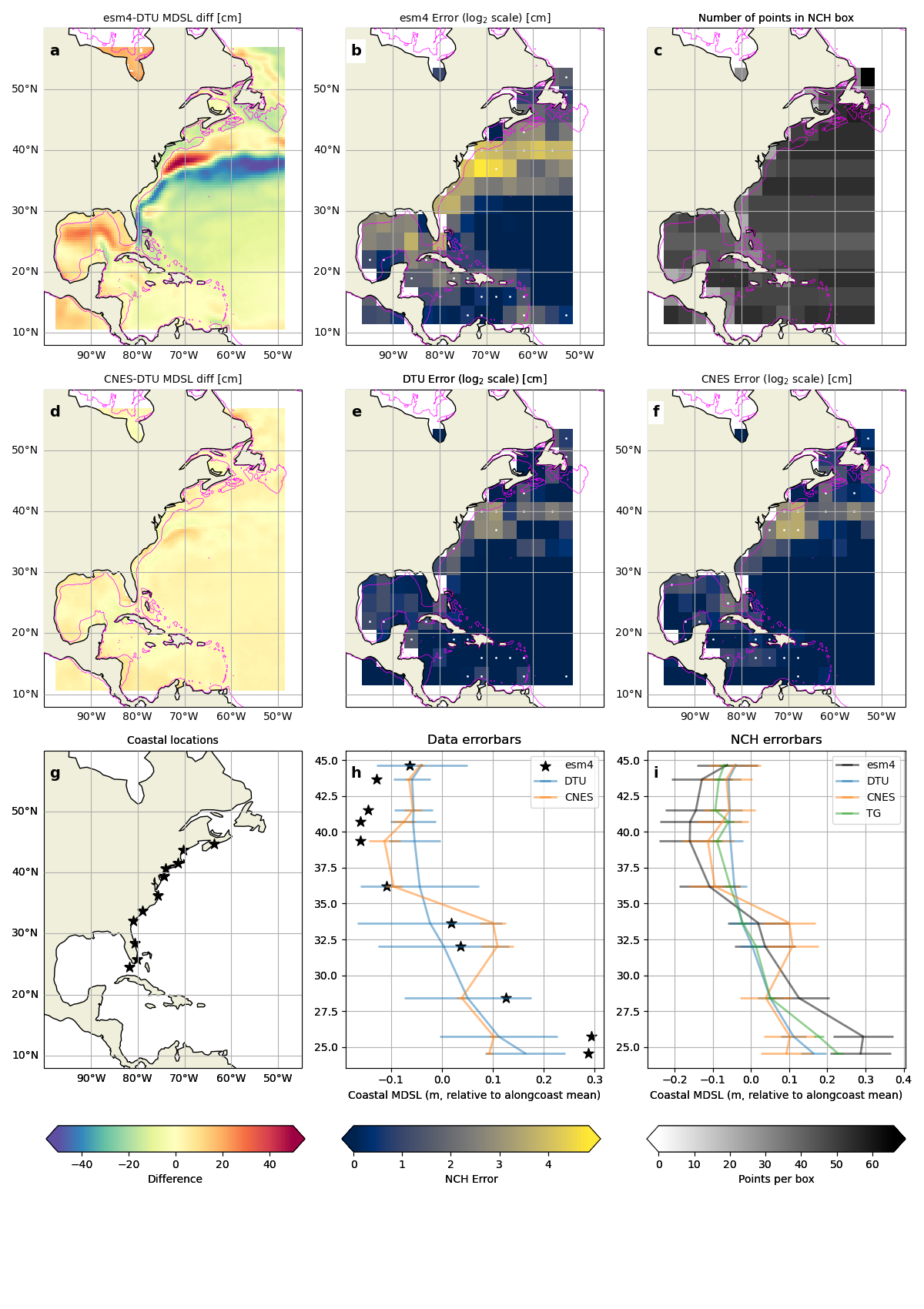
Figure 2: MDSL regional/coastal output for the Gulf Stream region. (a) MDSL difference between model and DTU reference data. (b) MDSL error of the model. (c) Number of points in an n-cornered hat box. (d) MDSL difference between DTU and CNES reference products. (e) MDSL error of DTU. (f) MDSL error of CNES. (g) Locations of the tide gauges used as reference to calculate the coastal NCH. (h) Coastal MDSL of tide gauges and reference products relative to the coastal mean. (i) Coastal MDSL error.

Figure 3: MDSL global output. (a) MDSL difference between model and DTU reference data. (b) MDSL error of the model. (c) Number of points in an n-cornered hat box. (d) MDSL difference between DTU and CNES reference products. (e) MDSL error of DTU. (f) MDSL error of CNES.
References
Zhao, M., Little, C. M., & Krasting, J. P. (In Review). An improved approach for evaluating ocean and climate model errors in mean dynamic sea level. Journal of Atmospheric and Oceanic Technology.
Contact info
PI: Christopher M. Little (clittle@aer.com), Atmospheric and Environmental Research Inc.
Current Developer:
Contributors: Mengnan Zhao, Sara Vannah, & Nishchitha Etige
Open source copyright agreement
Link the source file of the open source agreement.